Hurricane Warning: Strengthening Ian Targeting South Carolina Next
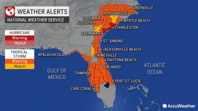
Hurricane warnings were issued along the entire coast of South Carolina on Thursday morning as AccuWeather forecasters warn that Ian will strengthen back into hurricane force over Atlantic waters before making its third landfall in the United States just south of Charleston, South Carolina, on Friday.
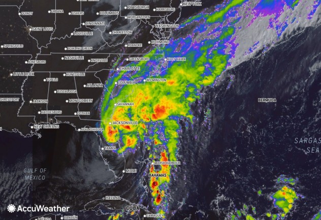
Ian lost wind intensity and was downgraded to a tropical storm early Thursday morning after turning deadly as it rampaged across Florida, causing a path of destruction and flooding. Ian emerged over Atlantic waters on Thursday morning and was spinning 25 miles north-northeast of Cape Canaveral, Florida. Ian’s maximum sustained winds were already increasing as it moved over water and were just shy of hurricane strength.
Life-threatening impacts will continue to spread northward across the Southeast as Ian charges over the Atlantic then back over land. Hazards will include flooding rainfall, dangerous storm surge, damaging winds and severe weather as Ian makes that trek.
Ahead of Ian’s arrival and as the storm pummeled Florida, states of emergency were declared across Georgia, South Carolina, North Carolina and Virginia. Tropical storm warnings were issued for coastal areas from Georgia to North Carolina.
Ian will continue to pummel central and northern parts of the Florida Peninsula into Thursday night, as it begins its path toward the South Carolina coast.
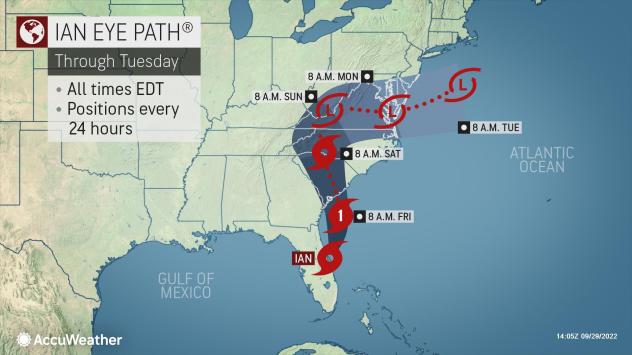
“Ian will cease its northeasterly track, turn northward then back to the northwest while over the Atlantic Ocean spanning Thursday night and Friday,” AccuWeather Chief On-Air Meteorologist Bernie Rayno said.
The system is expected to spend more than 24 hours over bathlike waters of the Gulf Stream just offshore of the Southeast. As it does so, its maximum sustained winds will continue to increase.
“Ian will regain hurricane intensity before moving onshore in South Carolina, perhaps just south of Charleston, South Carolina, late Friday afternoon or early Friday evening,” Rayno said.
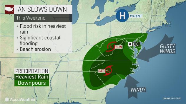
The worst conditions will be along the Carolina coast, where winds are predicted to be the strongest. The combination of torrential rain and storm surge will lead to a water rise of several feet along beach communities and cities that sit slightly inland.
Cities such as Charleston and Myrtle Beach, South Carolina, and Wilmington, North Carolina, will be at risk for a water level rise of 3-6 feet with locally higher levels from Friday to Friday night.
“The Outer Banks of North Carolina are particularly vulnerable to coastal erosion, and some areas have not recovered following a destructive storm back in the spring and ongoing impacts from climate change and rising seas,” AccuWeather Meteorologist Reneé Duff said.
As Ian drifts inland over the Carolinas this weekend, heavy rain will be pushed and pulled along as well. The risk of flooding rainfall is likely to stretch hundreds of miles away from the coast.
The greatest amount of rain, 8-12 inches with local amounts to 18 inches, can occur along the Georgia and South Carolina coasts, according to AccuWeather meteorologists. A secondary maximum of rainfall averaging 4-8 inches with local amounts near 1 foot is possible over the mountains and foothills of North Carolina, Virginia, northern Georgia, western Virginia and the eastern parts of Tennessee and West Virginia this weekend into early next week.
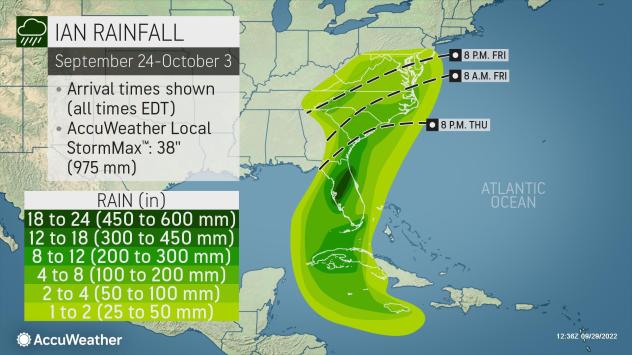
Rainfall of this magnitude is likely to trigger flash flooding of urban areas and small streams. Significant rises on some of the major rivers are possible as well. Even the major cities of Augusta, Georgia and Columbia in South Carolina and Charlotte, Greensboro and Raleigh in North Carolina will run the risk of flash flooding.
AccuWeathers forecasters say the storm is likely to lose wind intensity while over the Southeast states, but it will remain a dangerous rainstorm.
However, meteorologists will continue to analyze the storm’s future movement with the potential for different scenarios to play out. It’s possible that Ian will completely diminish over the southern Appalachians, or that it will loop over the Southeast states and perhaps even emerge over the ocean and develop once again off the mid-Atlantic coast.
The projected rainfall from Virginia to Georgia assumes that Ian will continue to take a steady track and lose wind energy, becoming a tropical depression and rainstorm. However, should the storm stall for several days, inland rainfall could double, and flooding problems could become widespread and potentially life-threatening.
Farther to the northeast, impacts from Ian will be significant along the mid-Atlantic coast.
“Areas from northeastern North Carolina and southeastern Virginia to coastal Maryland, Delaware and New Jersey will be subject to stiff easterly winds that will lead to above-normal tides, beach erosion and coastal flooding from Friday through Sunday,” AccuWeather Senior Meteorologist Joe Lundberg said.
The flow of air from high pressure over northern New England to low pressure associated with Ian will create strong winds that will push waters and waves from the Atlantic Ocean toward the coast.
“To potentially make matters worse, there is a chance that Ian finds a way to reach the mid-Atlantic coast and strengthen again, or perhaps a second new storm forms along the mid-Atlantic coast early next week, which would continue onshore winds and drenching rains with flooding and beach erosion problems for additional days,” Lundberg said.
The setup could lead to another pocket of heavy rainfall in the mid-Atlantic mainly south of Pennsylvania and New Jersey in either scenario. People in New York City may want to have an umbrella handy as the metro area will end up on the northern edge of the rain this weekend, but it is possible that steadier and heavier rain to shift northward early next week, forecasters say. A north-south distance of a few miles could mean the difference between a few sprinkles and torrential downpours for a time.
Rain gear will be required in Philadelphia, Baltimore, Washington, D.C., and Richmond, Virginia.
Produced in association with AccuWeather.
The Western Journal has not reviewed this story prior to publication. Therefore, it may not meet our normal editorial standards. It is provided to our readers as a service from The Western Journal.
Truth and Accuracy
We are committed to truth and accuracy in all of our journalism. Read our editorial standards.