A Fitness App Called Strava Is Compromising National Security Secrets
A feature found on a popular fitness tracking app has potentially unveiled the locations of once-secret overseas military bases.
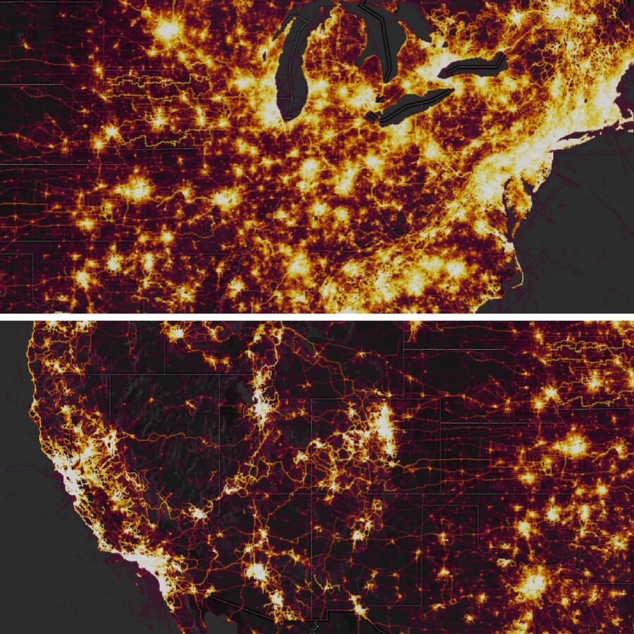
This past weekend, Strava, a company that runs a workout tracking app, released an updated version of an online map detailing the routes of 1 billion workouts conducted in 2017.
While the gesture may have been innocent in intent, it reportedly revealed the location of several U.S. military bases in Syria, Turkey and Yemen, as reported by Business Insider.
The fitness app, which tracks running and biking workouts, obtained the data from smartphones and other devices such as Fitbits in an effort to display the most traveled workout routes in a given area.
As can be seen below, New York City, Washington D.C. and Los Angeles are shaded bright orange, signifying a heavy use of routes in that particular area.
As noted by Business Insider, the use of workout tracking apps tends to “skew Western, you, and active,” and because of this, in countries like Niger, the map appears to highlight areas where U.S. military bases are present.
The app can reportedly be left on even when not being used for workout purposes, so a line specifying past whereabouts throughout a person’s whole day can be highlighted and made public.
This can lead to a frightening scenario where not only can people track the whereabouts of military members, they can see which specific military member made used which route, as Jeffrey Lewis of the Daily Beast points out.
He notes that using the data obtained from the app won’t just give away military base locations, but it can also reveal separate covert areas that one military member might travel to over time.
“Soldiers, remember, rotate from one assignment to the next,” Lewis wrote. “Which means Strava can continue to track each user as he or she rotates to the next assignment, burning one secret missile base after another with all those calories.”
It should be noted that the U.S. isn’t the only country to have its military bases potentially exposed.
Joggers near the South China Sea and workers on Taiwanese missile bases appeared to have their Strava data exposed as well.
The Guardian reported that the heat map revelation has prompted militaries around the world to consider banning fitness trackers in the future to prevent this scenario from occurring again.
On Monday, the Pentagon released a statement noting that it will be reviewing its safety protocols as result of the data release but did not reveal whether or not U.S. military personnel had used the app.
“The Department of Defense takes matters like these very seriously and is reviewing the situation to determine if any additional training or guidance is required,” the Pentagon stated.
Strava responded to news of the potential dangers brought forth from their heat map by solidifying their commitment to protecting the private information of its users, especially members of the military.
“We are committed to helping people better understand our settings to give them control over what they share,” the company stated, sharing a 2017 post detailing the eight steps users can take to protect their information.
The fitness tracking company added: “We take the safety of our community seriously and are committed to working with military and government officials to address sensitive areas that might appear.”
Advertise with The Western Journal and reach millions of highly engaged readers, while supporting our work. Advertise Today.
Truth and Accuracy
We are committed to truth and accuracy in all of our journalism. Read our editorial standards.