Big Weather Changes Are On The Way For The Midwest, Northeast
Winter is coming. The springlike spell of warmth has promoted record-challenging high temperatures during the first few days of 2023, but AccuWeather meteorologists say changes are on the way. Colder air along with the potential for some snow chances will arrive later this week into the weekend.
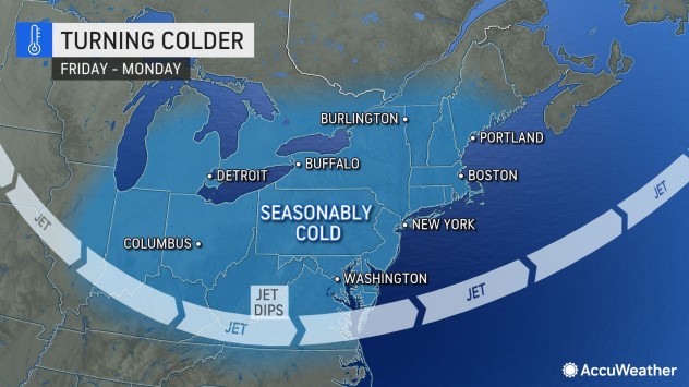
The change to more seasonable temperatures will be brought on by a small but fairly persistent southward dip in the jet stream. Ripples in the jet stream, associated with weak storm systems, will move along from the Midwest to the Northeast states and could trigger snow, a snow/rain mix or an icy mix across a fairly extensive area.
Even though temperatures will likely hover a few degrees Fahrenheit above average for early January, it will feel noticeably colder. The more seasonable air was already filtering across the Midwest as of midweek.
For example, the temperature peaked at 72 F in St. Louis on Tuesday. Already on Wednesday, temperatures were hovering about 30 degrees lower, in the 40s, on Wednesday afternoon with highs likely to remain in the 40s into early next week. The normal high is 41 for the Gateway to the West.
Farther to the east, highs in New York City have ranged from the lower 50s to the mid-60s from Dec. 29 through Jan. 4., but a downward trend is coming. Highs will be in the lower 50s on Thursday, before maximum temperatures in the 40s will be common from late this week to early next week, forecasters say. A high near 40 is average for the Big Apple in early January.

The colder air will soon be accompanied by wintry precipitation, especially across northern New England.
A push of cold air will sneak into part of southeastern Canada, upstate New York and northern New England Wednesday night and Thursday, AccuWeather Senior Meteorologist Brett Anderson said.
“At first, the cold air will be in the lower part of the atmosphere, and that can lead to freezing rain in a zone that includes Ottawa and Montreal, Canada, to Plattsburg, New York, and Montpelier, Vermont,” Anderson explained. Untreated surfaces can become sheets of clear ice, creating dangerous conditions for pedestrians and motorists. Enough ice could build up on trees and utility lines to trigger power outages.

As the layer of cold air deepens, a transition to snow will occur and expand southward to include much of western New York, central New England and coastal Maine on Thursday. Accumulations will generally be light, but a few spots can pick up 2 or 3 inches of snow.
As the pool of chilly air lingers in the Midwest and spreads into more of the Northeast, snow showers will become common and shift from the Great Lakes region to the central Appalachians and much of New England during Thursday night and Friday.

As a couple of pieces of energy break off from the California bomb cyclone and travel eastward across the Rockies and emerge over the Great Plains, just enough moisture may be drawn into the colder air to set the stage for additional rounds of winter weather from the mid-Mississippi and Ohio valleys to the mid-Atlantic region this weekend.
The exact timing and areal coverage of the snow and wintry mix is not yet set in stone as the first of the disturbances may fall apart as it moves into drier air before extending across the Appalachians.
However, a zone of snow and snow/sleet/rain mix is likely to develop from parts of Missouri to portions of Illinois, Indiana, Ohio and Kentucky early this weekend. Enough snow may fall in some locations to make roads slushy and slippery.
All or mostly snow may fall north of Interstate 70 to areas as far north as Iowa, southern Wisconsin and part of the Lower Peninsula of Michigan. These areas face a higher chance of experiencing snow-covered roads. It is possible that Chicago has a period of accumulating snow this weekend.

Since the second disturbance will have more moisture to work with, there is a better chance of some snow or a wintry mix to push across the central Appalachians and on toward part of the mid-Atlantic and New England regions from Sunday to early Monday.
How much, if any, slushy accumulation develops on roads and sidewalks east of the Appalachians will depend on whether or not the weak storm is able to grab Atlantic moisture at the last minute and gain strength quickly enough. The chance of slippery travel along part of the Interstate 95 zone is not zero for the Monday morning commute.
AccuWeather’s long-range team of meteorologists has been analyzing the potential for a large Atlantic coast storm during the period from Jan. 10-14 for weeks.
“As more energy from the Western states feeds eastward and provided a stronger dip in the jet stream forms inland from the Atlantic coast next week, a more substantial winter storm may evolve for the Northeast with areas of rain and heavy snow,” AccuWeather Lead Long-Range Meteorologist Paul Pastelok said. “The window for that is looking to be around Jan. 11 or 12 at this time.”
Temperatures do not have to be extremely cold for snow to develop. Snow can fall and accumulate with temperatures near or just above the 32-degree mark. A mixture of snow and rain can easily occur with temperatures in the mid- to upper 30s.
Pastelok said that a further dip in temperatures is likely in the wake of that larger storm next week, even if the storm ends up moving offshore, meaning that most of the precipitation would bypass the Northeast.
“A cold high-pressure area will move in later next week, but it is not likely to be extreme, like the cold the Northeast and many other areas of the nation experienced around Christmastime,” he said.
As that colder pattern evolves, there may be several days with highs in the 20s in the Appalachians and New England and the 30s elsewhere in the Ohio Valley and mid-Atlantic.
Produced in association with AccuWeather.
The Western Journal has not reviewed this story prior to publication. Therefore, it may not meet our normal editorial standards. It is provided to our readers as a service from The Western Journal.
Advertise with The Western Journal and reach millions of highly engaged readers, while supporting our work. Advertise Today.
Truth and Accuracy
We are committed to truth and accuracy in all of our journalism. Read our editorial standards.