Hurricane Ian: Behind The Numbers Of A Historic Storm

After a record-quiet August in the Atlantic, Hurricane Ian brought a swift contrast to end the month of September. The powerful storm left communities looking like war zones, cut power to millions and became the deadliest tropical system to hit Florida in more than 87 years. With the sheer magnitude of destruction the storm left in its wake, it is near certain that Ian has also carved its name into the annals of history.
Ian first formed as a tropical depression during the early morning of Sept. 23, just north of the island country Curaçao, located in the south-central Caribbean Sea. A few days later on Sept. 26, the storm officially became Hurricane Ian southwest of the Cayman Islands.
Nearly 69,000 people who reside in Grand Cayman were put under a hurricane warning leading up to Ian moving near the area. The first impacts of Hurricane Ian were recorded on the Cayman Islands on Sept. 26, where winds surpassed 50 miles per hour in several locations in the country, while high waves were seen in the west.

Ian continued its northward track on Sept. 26, and during the night strengthened to have maximum sustained winds of 105 mph — a Category 2 hurricane. This made Ian the strongest September hurricane in the Caribbean west of 75 degrees since Hurricane Felix in 2007, according to the NWS.
Fueled by warm Caribbean waters, Ian continued to rapidly intensify overnight Sept. 26 into Sept. 27, strengthening into a Category 3 hurricane with winds of 115 mph.
Ian crashed ashore Cuba’s Pinar del Rio province that morning with maximum sustained winds of 125 mph, 4 mph short of a Category 4 hurricane, and the impacts from its significant high winds and storm surge rippled across the western side of the island.
The storm cut power to all customers in the Pinar del Rio Province, which has a population of 850,000, and quickly spread to create a blackout across the entire nation. In Havana, located about 100 miles to the northeast of landfall, instruments recorded a wind gust of 87 mph. At least two people were killed in Cuba as a result of Hurricane Ian, according to CNN.

Despite losing wind intensity over western Cuba’s mountainous terrain, the storm still retained Category 3 major hurricane strength as it entered the Atlantic once more.
Ten hours later, Ian hit a maximum sustained wind speed of 155 mph, just 2 mph short of a Category 5 storm, after meeting the criteria for rapid intensification in just two and a half hours. Typically, the rapid intensification process takes closer to 24 hours.
Hurricane Ian was an unusually prolific lightning producer in its eyewall, so much so that several storm chasers were able to catch eyewall lightning on film for the first time.
Less than 24 hours after leaving Cuba, it was on Florida’s shores.
After reaching its peak strength, Ian lost an almost imperceivable amount of wind intensity before making landfall over Florida’s southwestern barrier island at 3:05 p.m. EDT on Sept. 28, with maximum sustained winds of 150 mph. At this level, Ian ranks as the fourth-strongest landfalling hurricane in the state’s history.
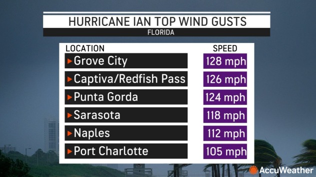
Ian was the first Category 4 hurricane to make landfall in southwest Florida since Charley in 2004. Top wind gusts recorded near landfall far exceeded 100 mph. The highest wind gust was in Grove City, Florida, where a 128 mph reading was measured by a WeatherFlow weather station. Other areas recording gusts over 120 mph included a NOAA station on Captiva Island at Redfish Pass and the Punta Gorda Airport.
Storm surge in Florida was forecast to reach up to 18 feet on the barrier islands and Fort Myers Beach. Official storm surge gauges operated by NOAA are widely separated in this part of Florida. One of the two gauges has been operating for at least 40 years in downtown Fort Myers and measured a preliminary record-high storm surge of 7.24 feet.
Another gauge at Naples Pier measured a 6.28-foot storm surge before the pier was seriously damaged and the sensor went offline. Determining how high the maximum storm surge reached will take NOAA months of surveying and research.
Storm surge damage was catastrophic on Captiva Island, Sanibel Island, Pine Island and Ft. Myers Beach, with residents lamenting it might take “another 20 years” to rebuild — a reference to the recovery from Hurricane Charley in 2004, which was never fully completed. In the coming days, evacuees from Sanibel Island returned to complete devastation, as did residents of Pine Island. The death toll climbed above 100 during the week following landfall, according to CNN Newsource, with one of the fatalities being a mother celebrating her 40th birthday.
Winds decreased as Ian moved over the state of Florida, but rainfall did not, creating what meteorologists call “freshwater flooding.” More than a dozen USGS river gauges across Florida exceeded the major flood stage with many of them setting new records.
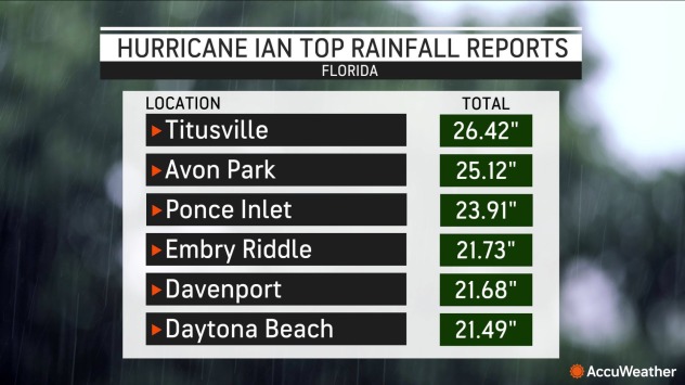
The highest rainfall total was recorded by a NOAA observer’s rain gauge in Titusville, Florida, located about 35 miles east of Orlando, which recorded a staggering 26.42 inches of rain from Ian. This is more than three times the amount of rain that typically falls in Titusville in all of September, which is 7.46 inches. Other rainfall amounts ranged from 20-25 inches in the Orlando area northeast to the coast around Daytona Beach, and 15-20 inches around landfall near Fort Myers.
Millions of people were impacted across the state, and citrus crop losses were estimated at up to 80 percent.
Ian weakened into a Tropical Storm as its center moved across the south-central east coast of Florida, but its destruction was far from over. Less than 10 hours after moving back over the Atlantic, Ian restrengthened into a hurricane and charted a course for the South Carolina coast.
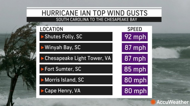
Ian’s maximum sustained winds strengthened to 85 mph before the storm made landfall southeast of Georgetown, South Carolina, 30 miles southwest of Myrtle Beach. Wind gusts exceeding 85 mph were reported on the coast, including on Shutes Folly Island in Charleston Harbor, where a 92 mph gust was reported by a WeatherFlow station. Another WeatherFlow station at Winyah Bay, located about halfway between Charleston and Myrtle Beach, reported a gust of 87 mph.
Storm surge affected many areas on the Georgia, South and North Carolina coasts, destroying boardwalks, damaging piers and causing coastal erosion. A storm surge gauge at Wrightsville Beach, North Carolina, preliminarily recorded a maximum surge of 4.03 feet , the second-highest water level ever recorded at the station, only exceeded by Hurricane Florence in 2018 which pushed the gauge to 4.11 feet . At Fort Pulaski, Georgia, a storm surge was recorded as high as 3.85 feet , exceeding all records for the station except for Hurricane Irma in 2017 and Hurricane Matthew in 2016.
Over 10 inches of rain fell in a narrow stripe inland north of Ian’s landfall in South Carolina. The city of Charleston reported 8.14 inches of rain from the storm, but amateur rain gauges reported totals as high as 10.75 inches on James Island.
More than 600,000 customers across the Carolinas were without power at peak on Sept. 30. By the next morning, more than 200,000 customers remained without power in North Carolina. At least five fatalities from Ian were reported in North Carolina, according to CNN Newsource.

After making landfall in South Carolina, Ian weakened into a tropical rainstorm as it moved northward into North Carolina. While Ian lost its tropical features, its energy contributed to a nor’easter forming off the Mid-Atlantic coast. As a result, this “ghost of Ian” caused heavy rain and coastal flooding from the North Carolina coast all the way north into southern New England.
Rain impacted several football games in Pennsylvania, including a college game between Northwestern and Penn State in State College, Pennsylvania on Oct. 1 and an NFL game between the Jacksonville Jaguars and Philadelphia Eagles in Philadelphia on Oct. 2.
The highest reading measured from a rain gauge was at Barnegat Township, New Jersey, which recorded 10.67 inches of rain between Oct. 2 and Oct. 5, but this included some rain from a cold front ahead of the Nor’easter.
Looking back on Hurricane Ian’s journey.
Advertisement - story continues belowAcross the Caribbean, through the Gulf of Mexico, and into the Southeast U.S. pic.twitter.com/qoM8CSDiit
— CIRA (@CIRA_CSU) October 7, 2022
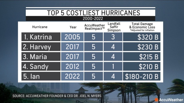
As a whole, the economic fallout is expected to rival some of the worst hurricanes in U.S. history. AccuWeather Founder and CEO Dr. Joel N. Myers said the total losses caused by Hurricane Ian will amount to between $180 billion and $210 billion in the U.S., putting it around his estimates for Hurricane Sandy (2012) which had total losses of $210 billion, adjusted for inflation.
Over 3.2 million customers lost power in the region at one point, according to the Edison Electric Institute, which also reported that 44,000 electrical workers from 33 states were deployed to help. Hurricane Ian resulted in at least 131 deaths, according to CNN Newsource.
Produced in association with AccuWeather.
The Western Journal has not reviewed this story prior to publication. Therefore, it may not meet our normal editorial standards. It is provided to our readers as a service from The Western Journal.
Advertise with The Western Journal and reach millions of highly engaged readers, while supporting our work. Advertise Today.
Truth and Accuracy
We are committed to truth and accuracy in all of our journalism. Read our editorial standards.