Unseasonable Warmth To Return After Record Lows, December-like Cold In Central, Eastern US

A big change in the weather pattern will bring a return of summerlike warmth to some locations over the Plains and Midwest and above-average temperatures to areas farther to the east later this week and weekend AccuWeather meteorologists say. This warmup will follow the reality check issued by Mother Nature this week that reminded folks that winter is not that far away over much of the central and eastern United States.
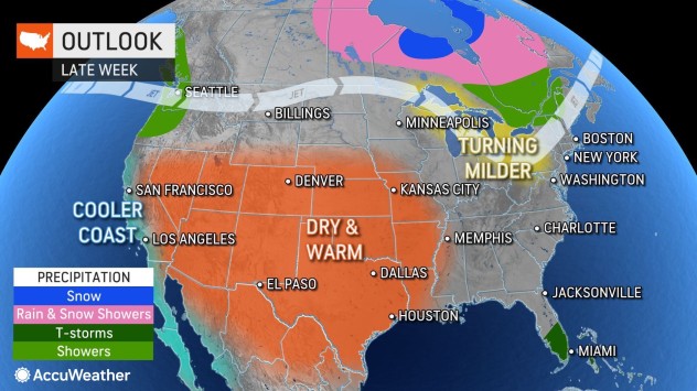
As a southward dip in the jet stream brings colder, more seasonable air into the West, a northward bulge in the jet stream will open the door for much warmer air to flow across the central and eastern U.S and put an end to the ongoing chilly weather.
A record low temperature of 16 degrees was recorded in Omaha, Nebraska, Tuesday morning, and lows in the teens are predicted once again Wednesday morning. However, temperatures will skyrocket during the balance of the week and this weekend.
High temperatures in Omaha will trend upward through the 70s later this week and will peak well into the 80s, perhaps challenging a more than 120-year-old record Sunday. The current record high for Oct. 23 of 84 was set back in 1899.
It will be a similar turnaround over much of the Plains and Mississippi Valley during the latter half of this week and this weekend as the large batch of cold air retreats northward into Canada.

AccuWeather forecasters say high temperatures in the mid-40s and AccuWeather RealFeel® Temperatures in the 20s and 30s are expected in Chicago Tuesday. As the week progresses, highs will trend upward through the 50s Thursday, and into the 70s Friday, Saturday and Sunday.
A temperature rebound of 50-70 degrees will take place over the Central states when comparing the lows of Monday and Tuesday to the forecast highs in the region this weekend.

Warmer air is coming to much of the East as well, but a storm that brews over the nearby Atlantic will play a factor in how warm it becomes.
Initially, in New York City, temperatures will have little trouble rebounding from levels about 8-15 degrees below the average in the mid-60s from Tuesday to Thursday to roughly 5 degrees above average or so this weekend. Midweek highs in the 50s in Washington, D.C., will be replaced with highs in the 70s this weekend. The average high in the Nation’s capital during this part of October is in the upper 60s.
How long the warming trend is paused will depend on the track, intensity and scope of the Atlantic storm. Should the storm become strong, it could knock temperatures down by 10-15 degrees or more with wind-swept rain. On the other hand, if the storm remains weak or mostly out at sea, the warming trend may simply be paused for a couple of days due to cloud cover, spotty showers and a breeze.
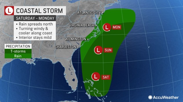
The Atlantic storm’s influence may be limited a bit farther west. Multiple days of sunshine are likely, or at least a string of days without any rain, are in store from the Appalachians to portions of the Great Lakes, Ohio Valley, Tennessee Valley and the central Gulf Coast region.
Around Atlanta, record-challenging lows in the 30s through Wednesday night will be followed by progressively milder nights into this weekend. By Saturday night, low temperatures will be close to the average in the low 50s.
Daytime highs will trend more slowly upward in Atlanta and much of the Appalachians when compared to the Plains and Mississippi Valley into this weekend. By Friday, highs will be just shy of the average in the upper 60s. However, highs in Atlanta are projected to be in the mid-70s by Sunday.
During next week, unseasonable warmth is expected to become widespread in the eastern third to half of the U.S.
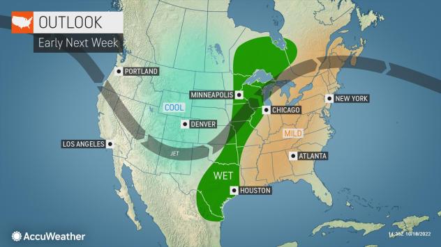
Soon after warmth builds over the Plains and Mississippi Valley into this weekend, colder air will take control over the West. As the leading edge of this colder air attempts to push farther to the east, it could unleash severe thunderstorms. Any storms that simply provide soaking rainfall would be more than welcome over the Mississippi River basin and its major tributaries such as the Missouri and Arkansas rivers.
Water levels have reached historically low levels in some areas and are near record-low levels in many other locations along the Mississippi from Missouri and Illinois to Louisiana. Levels are so low they are adversely affecting the vital transport of grains, commodities and industrial products.
Produced in association with AccuWeather.
The Western Journal has not reviewed this story prior to publication. Therefore, it may not meet our normal editorial standards. It is provided to our readers as a service from The Western Journal.
Truth and Accuracy
We are committed to truth and accuracy in all of our journalism. Read our editorial standards.

Advertise with The Western Journal and reach millions of highly engaged readers, while supporting our work. Advertise Today.


