AccuWeather Forecasters Study New Areas For Development In Atlantic As Karl Heads For Mexico

Tropical storm warnings were issued for parts of Mexico on Thursday as Tropical Storm Karl continued to drift southward over the southwestern Gulf of Mexico. Although Karl is currently the only named system in the Atlantic, AccuWeather meteorologists caution that the Atlantic hurricane is far from over, and there remain areas to watch for development in the coming weeks.
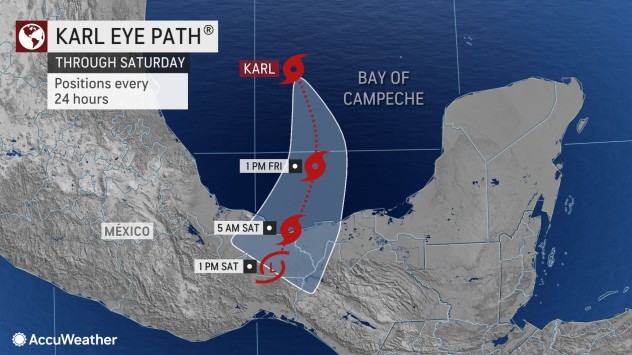
Karl came close to becoming a hurricane for a time on Wednesday when its maximum sustained winds peaked at 65 mph (105 km (344505.00 feet s) (344505.00 feet)/h), just 9 mph shy of Category 1 hurricane status. The storm has meandered over the same portion of the Gulf since it formed on Tuesday afternoon and has likely already peaked in intensity. Karl began to drift southward on Thursday and is forecast to pick up momentum prior to its forecast landfall in southern Mexico.
As of 10 a.m. CDT on Thursday, Karl’s maximum sustained winds were at 50 mph (85 km (278885.00 feet s) (278885.00 feet)/h), and the storm was moving south-southeastward at 5 mph (7 km/h). Tropical-storm-force winds extend outward 80 miles (130 km (426530.00 feet s) (426530.00 feet)) from the center.
A landfall farther to the east in Mexico when compared to forecasts earlier this week is anticipated of the meandering storm. The center is projected to come ashore well east of Veracruz, perhaps near the port city of Coatzacoalcos, Mexico, on Saturday.
Because of the storm’s rare southward track toward this part of Mexico, conditions may be more severe when compared to a storm that forms and heads quickly to the north or west, AccuWeather meteorologists say. The slow movement of the storm will cause rough surf for an extended period throughout the shoreline of the southwestern Gulf.
AccuWeather forecasters have rated Karl as less than one on the company’s RealImpact™ Scale for Hurricanes in Mexico. A tropical storm warning was in effect in Mexico from Alvarado to Ciudad del Carmen along the shores of the Bay of Campeche.
While the heaviest rain may initially be east of the storm’s center, downpours will expand westward and inland soon after it makes landfall. A general 4-8 inches (100-200 mm (0.66 feets)) is forecast with an AccuWeather Local StormMax™ of 14 inches (360 mm (1.18 feets)) possible along the coast and well inland over the mountains.

Wind gusts are likely to range from 40-60 mph (60-110 km (360910.00 feet s) (360910.00 feet)/h) within 100 miles (160 km (524960.00 feet s) (524960.00 feet)) or so of the center at landfall and are likely to trigger sporadic power outages and property damage.
There is a chance that Karl may dip below tropical storm status prior to making landfall, in which case gusty winds would be less intense but still potentially damaging. However, downpours may continue to pose a significant threat to lives and property due to the potential for flash flooding and mudslides even in a reduced tropical rainstorm state.
As Karl moves inland and loses wind intensity this weekend and beyond, AccuWeather meteorologists will continue to monitor the Atlantic for other areas of potential tropical trouble.
“We have a little break coming up in the Atlantic as far as tropical activity is concerned, but it may not last too long,” AccuWeather Chief On-Air Meteorologist Bernie Rayno said.

“The second half of October through November is a time when we see tropical disturbances (tropical waves) that originate from Africa become less in number and less robust,” AccuWeather Senior Meteorologist Joe Lundberg said. “However, there are still areas that bear watching during the final weeks of the hurricane season, such as homegrown systems.”
These homegrown systems tend to form relatively close to North and Central America in parts of the Atlantic Ocean, such as the Caribbean Sea, the southern Gulf of Mexico and just off the Atlantic coast of the United States.
There are no candidates for tropical systems over the next week or so at least, but that can change over time as other conditions and non-tropical weather systems organize and move along, Lundberg said.
As large southward dips in the jet stream become more prominent in the eastern U.S. during October and November, a spin-off weather system typically tends to develop farther south.

That system is known as a gyre or broad area of slowly-spinning air and low pressure. Because of lower pressure and weak spin, it can sometimes help induce a tropical system.
“One spot where we will be watching for development in the next few weeks will be around the Caribbean,” Rayno said.
Formation in this area can get a little boost as remaining tropical waves from Africa move into the region from the east.
Even though Karl formed as a result of leftover energy from Hurricane Julia, rather than a result of direct impact from a gyre, it is an example of how quickly a tropical storm can brew under the right conditions with low wind shear and a pocket of moisture.
If additional tropical storms form this season, the next three names on the list forecasters use to identify storms are Lisa, Martin and Nicole.
Produced in association with AccuWeather.
The Western Journal has not reviewed this story prior to publication. Therefore, it may not meet our normal editorial standards. It is provided to our readers as a service from The Western Journal.
Truth and Accuracy
We are committed to truth and accuracy in all of our journalism. Read our editorial standards.

Advertise with The Western Journal and reach millions of highly engaged readers, while supporting our work. Advertise Today.


