Frequent Downpours To Threaten Flash Flooding In Texas, New Mexico

Two weather systems will work together to produce a large area of soaking rain and raise the risk of flash flooding in portions of the south-central United States that are in need of rainfall following months of drought, AccuWeather meteorologists say.
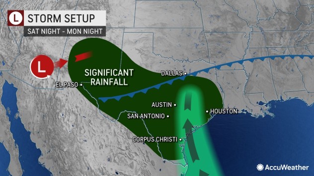
The same storm that produced spotty thundershowers in Southern California on Tuesday and the same strong cold front responsible for producing severe weather in the Midwest will join forces over portions of the southern Rockies and Plains for several days spanning from Sunday to at least next Tuesday.
Parts of Texas and New Mexico could receive upwards of 6 inches of rain in the coming days.

“As the front stalls over the southern Plains region, the storm from Southern California will drift eastward,” AccuWeather Meteorologist Matt Benz said.
The circulation from the storm will pump moisture northwestward from the Gulf of Mexico, while the stalled frontal zone will allow downpours to continuously drench the same areas, Benz explained.
Meteorologists say the front is likely to crawl southward this weekend into early next week, and the slow forward speed and amount of moisture can lead to both beneficial and excessive rainfall.
A general 1-3 inches of rain is forecast from central New Mexico to the central Texas coast. However, within this zone, double that amount of rain is likely from south of Midland through San Antonio and perhaps to the metro areas of Victoria and Corpus Christi, Texas. The rainfall will help boost water levels in some reservoirs and rivers that have been dwindling.
Too much of a good thing is possible as well. Forecasters caution that there is a risk of water spilling over small streams and river banks. Should the setup develop to its full potential, some areas could be looking at rain in excess of 6 inches over a several-day period.

Urban locations, normally dry stream beds and low water crossings are likely to face flooding problems, forecasters warn. At the very least, the rainfall will produce some travel delays in the region, and motorists may need to seek alternative routes to their destination
San Antonio and many other locations could stand a thorough soaking. The San Antonio metro area has received only about 32% of its normal rainfall since the start of the year. Rainfall totals so far this year across Texas range from about 25% of normal in the driest locations in the central part of the state to near 100% near the New Mexico border.
Soil conditions are about average in the lower Rio Grande Valley region of Texas, but exceptional drought continues to plague parts of the central and western parts of the Lone Star State.

Back in mid-August, a tropical rainstorm moved westward from the Gulf of Mexico through South Texas and into northern Mexico. The rainstorm fell just short of becoming a tropical storm before landfall and unloaded 6-12 inches of rain on South Texas, which wiped out drought conditions in the region.
While there is a chance that a small amount of moisture leftover from Tropical Storm Karl, which was spinning over the southwestern Gulf of Mexico on Wednesday, may find its way northward along the Texas coast this weekend, it is unlikely to have a significant impact on rainfall in the area. Karl is forecast by AccuWeather meteorologists to make landfall in east-central Mexico late Friday.
A very active North American monsoon season delivered a substantial amount of rainfall this summer in parts of the interior Southwest with much of New Mexico benefiting from nearly daily downpours during July, August and September. Although normal annual rainfall in this region is substantially less than many other areas of the U.S. and on the order of several inches, the monsoon has put a dent in the long-term drought conditions.
The region from New Mexico through much of Texas can benefit from non-flooding rainfall, but as is often the case when it rains in this part of the nation, too much rain can fall too fast and lead to flooding.

Some rain is also forecast to extend farther to the east along the frontal zone for a time. Most of the showers and thunderstorms will occur into the end of this week from the lower Mississippi Valley to the southern Atlantic coast.
However, some resurgence of moisture and spotty rain is likely in the South Central states, including parts of Oklahoma and Arkansas, as the California storm moves eastward and pulls the front northward for a time later this weekend to early next week.
Produced in association with AccuWeather.
The Western Journal has not reviewed this story prior to publication. Therefore, it may not meet our normal editorial standards. It is provided to our readers as a service from The Western Journal.
Truth and Accuracy
We are committed to truth and accuracy in all of our journalism. Read our editorial standards.
Advertise with The Western Journal and reach millions of highly engaged readers, while supporting our work. Advertise Today.


